Wednesday, June 27, 2018

The Other Sisters

So, this post will be a bit of a conglomerate of photos from several different trips from several different time periods but it will be all about the other two sisters of the Three Sisters Range to give a better perspective of why I am so infatuated with them.

Unfortunately, I have lost some photos from a Bessie Peak trip so can't show too much of her until I ask my friend Quentin if I can post his photos from that trip.  Anyway, let's meet Virginia's sisters!


Hopefully this sister looks familiar as she was the subject of the Virginia Peak post.  This is the north side of the Virginia Peak complex from the subalpine slopes leading to the summit of Helen Peak.  I explored Helen Peak during an overnight trip in July of 2014 which seems so long ago now!  This view is looking at Virginia's north side so I was looking to the south in this photo.


This is Bessie Peak and her daughter Bessie Junior looking at their south sides which means I was looking north (more northwest actually).  Helen Peak is between Bessie and Virginia, Bessie to the north, Virginia to the south.
Keep those lakes in mind as I will be talking more about them in a bit.  For whatever reason, I refer to them as Helen Lakes.


Just another view of Virginia before moving on further up the approach to Helen's summit.


It is still a fairly long way to the top of Helen Peak from this spot and at the time, I was ignorant as to the best, most efficient route to the top and thought traversing the north side of the ridge would save me A LOT of elevation gains and losses from going up and over the several high points along the ridge.  As seems to be the case with most things in life, trying to shortcut or cheat ultimately makes things more difficult in the long run and trying to traverse beneath the ridge was one of those cases as I kept getting stopped by impassable sheer rock faces causing me to either backtrack or climb straight up to the top of the ridge.  Trying to save time cost me more time and gave me at least two different high pucker factor moments that I would have been happy to have not experienced!  A bit of advice to those thinking about hiking in the high country of Southeast Alaska --  follow the animal trails!!  They know where the best routes are and have travelled them for many, many, many years.  I didn't say the animal trails are necessarily safe, easy, or for the casual hiker, but they do follow the BEST route.


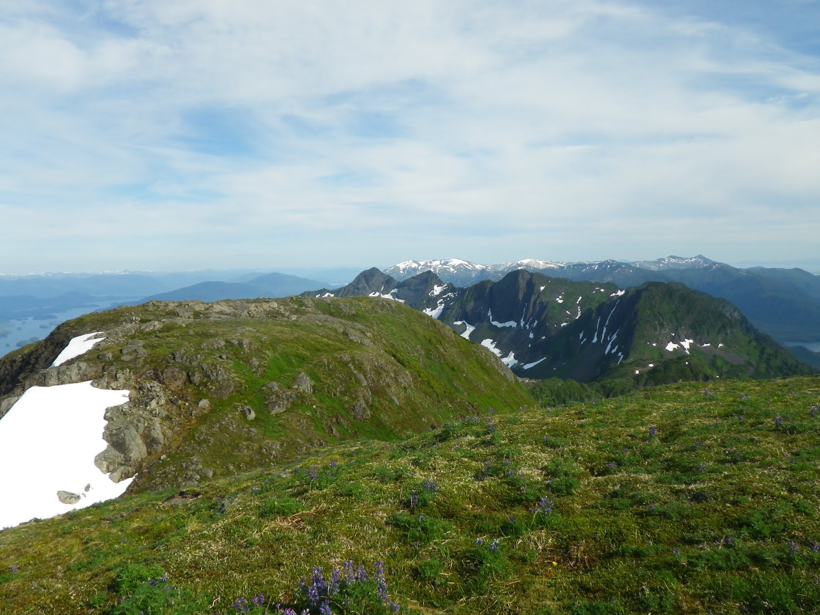
That is Helen Peak close to the center of this photo with a beautiful alpine lake below.  I hope to get to that lake someday in the future.  The shoulder of Bessie is just in frame on the right.


These two photos are of one of the Virginia complex peaks .


More of Helen's summit from a little bit closer.  The bottom photo has Helen on the left with Bessie and Bessie Junior on the right.  


A Sitka-black tail buck and Virginia Peak.  I don't remember now just how many deer I saw on this trip but I do remember seeing at least 8 different bucks and at least as many does.  I honestly don't think any of these deer have ever seen a human before as the ones I was fairly close to didn't run away or actively approached me with very curious demeanors.  This buck in particular followed me for several minutes.  In the Virginia Peak post, I mentioned the fact that I know people who have been to the top of Bessie and Virginia but have personally never heard of anyone going to the top of Helen, the behavior of these deer was proof that humans very rarely venture into the alpine of Helen Peak.  In the bottom photo, the peak on the left is where I spent the night on my recent Virginia Peak trip.


There's the summit of Helen very close now with a deer trail leading right to the summit.  The summit of Helen is very broad with plenty of room to have a few dozen people.  It would be a great place for a wedding!  (And that probably explains why I have never been married better than I could ever explain!)


Bessie Peak from the summit of Helen Peak.  Look at that left side of Bessie!!  Wholly crap that is steep!  I can't believe I descended that with a big, heavy pack and then went down that descending ridge leading to the left, into that valley and then up the other side to Red Mountain!!  Sometimes I wish I had hobbies that were easier!  I expect to have artificial knees in the not so distant future!!

The view south from Helen's summit.


Another view to the south of the Virginia complex.


This is the view kind of to the southeast from Helen's summit.  On this trip, I camped on the vegetated knob to the left of the light gray colored knob above the lake.  This was a long hike!


A musk ox on the summit of Helen Peak?  This is Musty the musk ox my mountain climbing and adventuring mascot.  Yeah, I don't have a good explanation, it just became a thing.  That is Bessie Peak in the background.


Virginia Peak complex from Helen Peak


A view of the ridge leading to the summit of Virginia Peak.  The bears contemplating making little bears that I watched on the Virginia Peak trip were in the area in the bottom center of this photo.


The upper lake and its outlet looking down into the valley where Helen Lakes lie.


This pile of rocks is actually much more than a pile of rocks.  It is really more of a mystery than a pile of rocks.  The pretentious way of saying "pile of rocks" is cairn, it is also the more efficient way to type "pile of rocks" so I will refer to it as a cairn for the rest of this discussion.  These cairns are found throughout Southeast Alaska in the high alpine areas and are particularly well known in the Stikine River valley, my experience has also shown that they are prevalent in the Three Sisters Range as well.  I have found them on all of the sisters, Bessie, Helen, and Virginia, and on Red Mountain where there are quite a few of them with some of them being quite large requiring quite a bit of effort to build.  That was quite a few quites in that last sentence. These cairns are also obviously very, very old as determined by the growth of lichens on them that almost seem to hold the pile together like some sort of living mortar.  The most accepted theory as to what these cairns are, and the theory that makes the most sense to me personally, is that they are ancient route markers marking routes of travel when this land was covered by massive glaciers thousands of feet thick.  Contemporary geological evidence shows that most of Southeast Alaska was covered by ice sheets in the somewhat recent past with the exception being the very western coast and islands of SE AK.  My thought is that these cairns could have been route markers for some route into the interior of the mainland.  Interestingly, but very unscientifically proven, it seems to me from my explorations of the Three Sisters that the cairns I have found on Virginia, Helen, and Bessie's eastern ridges seem to line up fairly well with each other like they were some kind of waypoints to be lined up to reveal the route to cross the glaciers that must have filled the valleys separating the sisters from each other.  But, who knows?


Photos of Helen on the left and Bessie on the right with Helen Lakes between them.

These next several photos will take us out of the alpine and down to lake level.


This is not a particularly interesting photo but it helps to explain the upcoming ones.  This is Kunk Lake which is a pretty 1.3 mile hike from the saltwater on a human trail to a 3 sided shelter with an outhouse and woodshed.  There is also a rowboat provided allowing hikers to travel on the lake.  This is the view from the shelter with the long ridge leading to Helen Peak visible on the skyline, Helen Peak is the broad peak a little off center in the photo.  That ridge was the one I was hiking in the previous photos.  This next series of photos was from a trip that I did about 3 weeks ago in which I kayaked from Wrangell Island over to Etolin Island and the Kunk Lake trail, hiked up the trail to the shelter, rowed the rowboat across the lake to a spot roughly one quarter of the way into the this frame from the left side, hiked over to the creek that flows out of Helen Lake, hiked up that creek to Helen Lake with my packraft which is a small inflatable rubber raft, and then paddled around Helen Lake.  This trip, mainly the hike up the creek to Helen Lake, kicked my ass!  Scouting this trip from maps and Google Earth showed me that the creek flowed through a small gorge after it left the lake so I expected it to be difficult but I underestimated it a little.


Although I admittedly underestimated the difficulty of this trip, I did achieve my goal of getting to the lake.  I got to the lake much wetter and colder than I had hoped though which made me alter my plans fairly significantly.  That is Bessie and Bessie Junior in the distance.


I paddled to the far end of this lake with the intent of hiking to the other lake beyond this one with the packraft and paddling it.  This didn't happen.  The weather changed enough to be a deciding factor with clouds moving in front of the sun and a strong wind springing up.  By the time I got to the far end of the lake, I was pretty cold and my teeth were beginning to chatter a little.  I had a dry change of clothes with me so I wasn't too worried about hypothermia, my main concern was how I was going to get back to Kunk Lake from this lake as I DID NOT want to have to hike back down the creek through the gorge which I hiked up.  Hiking up the creek through the gorge required ascending two spots that I really did not want to have to negotiate going down and I fell twice on the way to the lake which could have resulted in injuries but fortunately did not.  I was somewhat certain that I could find a way out of this lake and back over into Kunk Lake but was concerned that I would not find one which would force me into retracing the hike down the creek through the gorge which filled me with a moderate level of worry and anxiety.  What I'm trying to say is, this wasn't a carefree day of frolicking in the woods, my body temperature was lowered, my anxiety level was heightened and my return trip was very uncertain so I did not accomplish my goal of getting to both lakes.  So be it and thank you for the lesson in humility Nature!


A closer look at Bessie.


A seagull nest on a log at lake level.  I think the gulls were too surprised to see a human here to harass me from their nest as they just flew above me rather quietly.


This is the outlet "creek" from the higher lake below Helen Peak that was in a few of the photos earlier in this post.

One last photo of Bessie.  The lake that I did not make it to is just on the other side of the trees on the bottom left of this photo.  It wasn't very far away from the edge of this lake but it didn't feel like a wise decision at the time for me to hike to it and in hindsight, while I'm disappointed I didn't get to it, I think it was the right choice for me to have made.  I did find a different way to get back over to Kunk Lake that was much safer and slightly easier than going back down the same way I came up so now I know how to get back here again in the future to get to that other lake!!  Stay tuned.

Friday, June 22, 2018

Virginia Peak

 My favorite mountains in the Wrangell area are called the Three Sisters.  This is a group of distinct and dramatic mountains on nearby Etolin Island really consisting of 5 mountains rather than just the 3 sisters, in fact, it is a family of mountains with a mother and father, the 3 sisters and the child of one of the sisters.  The three sisters are the most dramatic ones of the family and at least one of them is visible from many vantage points near the town of Wrangell which has made it impossible for me to not spend time exploring them over the years.  I recently got to the top of the last of the sisters that I had yet to summit and although she was the last, she most definitely was not the least!
Some quick information about these mountains and then I'll get to the good stuff - the photos!
The mountainous family consists of Red Mountain, the father and the highest of them at 3920' with his mate Alice Peak nearby at 3500'.  The sisters consist of Bessie Peak at 3915', Helen Peak at 3856', and Virginia Peak at 3760'.  Virginia is the subject of this post and was the last of the sisters that I had yet to summit.  Although I have been close to the summit on a couple occasions during deer hunting trips, getting to within a couple hundred feet from the top once, I had never been to the very top which was a situation I decided to remedy recently.
A spell of very nice, summertime weather coincided nicely with my days off from work on Tuesday and Wednesday, so I geared up to hike to the top and spend the night.  My previous trips to Virginia involved hiking up with fairly heavy packs with camping and hunting gear followed by hiking down with even heavier packs packed with the results of successful hunting trips.  A climb of Virginia Peak goes from sea level to 3760' in about 2 and a half miles of horizontal distance resulting in a pretty sustained steep hike which with a heavy pack is known to be a spirit crushing endeavor, my first hunting trip on Virginia resulted in my friend Nate and I both hiking down with packs ranging from 100 to 115 pounds as we were too successful in our hunt and shot 3 deer between just the two of us.  I was happy to be hiking Virginia solely for fun so went as lightweight as possible with only a bivy sack, sleeping bag liner, sleeping pad, a warm coat, a rain coat, minimal food, binoculars, camera, water, and my bug hut which is just a mosquito net with a couple of tent poles.
Alright, enough chitchat I guess, on with some photos!


This is Virginia from the ocean.  She doesn't look like much from this perspective but bear with me, it gets better.


These photos were taken from about the halfway point of the hike, maybe more like 5/8 of  the way up.  For future reference, the right side of these photos is north, the left side is south.  The hike up involves going up the ridge in the foreground to the right.  There is a pretty significant drop to the north of it offering some good views of the other sisters and of the valley between Virginia and Helen which is the next sister to the north.


This was my first wildlife sighting of the trip seen as I was looking to the north into the valley between Virginia and Helen.  These two black bears were on a small "plateau" type area about 200 feet below me.  June is mating season for black bears and mating was what at least one of these two bears had in mind.  This was a male bear patiently or persistently? or doggedly? or annoyingly? following a female bear with making little bears on his mind.  The female never showed much interest or disinterest in the male, she just kept a pretty uniform distance ahead of him as I watched these two for about an hour until they went out of sight over the horizon.  This was interesting to watch and provided me with a very funny (to me anyway) hypothetical narrative as to what these bears might have been saying to each other were I to give them a comedic human personality.


Getting closer.  These snowfields are on the south side of the mountain on what I will call the summit plateau for future reference.  There is some awesome deer hunting up there!


A first view of the family.  Starting from the right there is Bessie Peak, then Helen peak, then Red Mountain and Alice Peak.  The small knob to the right of Bessie is what I think of as Bessie's daughter and have always called Bessie Junior.


A closer view of Bessie and Helen.


Bessie and Bessie Junior.  I have been to the top of Bessie twice which involves hiking the ridge leading to the right and going up and over Bessie Junior, there is no safe way to traverse around Junior, you have to follow the deer trails up and over.


These three photos were taken from a narrow false summit ridge that I wanted to explore as I have seen giant bucks up here on past hunting trips.  There were two spots along this ridge that required me to intensely focus on the present moment as this deer/bear trail clung traversed a couple spots that a hiker would not want to stumble on.  I particularly like the orange rock and the blue sky in the bottom photo.  War Eagle!!


Almost at the same elevation as Virginia's summit here but getting to the summit required losing about 600' in elevation to then reclimb it to get to the top.


Proof that calling this a deer/bear trail was accurate.  A precarious perch for a poop!  When I saw this, I thought about how much it would suck to run into a bear on this narrow ridge where neither one of us would have any good options to avoid the other.  Fortunately there were no bears up there that day.


An even closer view of Bessie looking at her south side.  Bessie is the prettiest and most dramatic of the family.  I particularly like her red stripes of rock.  The first time I summitted Bessie, my friend Quentin and I descended the left side in this photo to cross a valley and then summit Red as well.  It was a long two day trip and that left side of Bessie was as steep as it can get without being a sheer wall.  It was another place to be very focused on the present moment!


Helen is not as pretty and dramatic as Bessie but she is the more remote and inaccessible of the whole family.  Getting to the summit was a long hike with a lot of elevation gain and loss as the only safe route was up and over several smaller "peaks" on the way.  I know other people who have been to the top of Bessie and Virginia but personally do not know anyone other than myself who has enjoyed the view from Helen. 


The patriarch of the family, Red.


And the matriarch, Alice.  Alice is the only peak in the family that I have not been to the top of which is something I intend to change in the future.


This is the view of the saltwater looking south showing the part of Zimovia Strait known as the Village Islands.  The top photo is at low tide showing the many navigational hazards in the area that have caused many a mariner some woes while the bottom photo is at high tide conveniently hiding those hazards.


All three of these peaks are part of the Virginia Peak complex with the one on the left being the highest and true summit.  That is where I spent the night.


Looking north from Virginia's summit at the hidden gem of Southeast Alaska and the last river of its kind in North America - the town of Wrangell and the Stikine River.  This great land of Alaska has a way of making our human presence look minor and fleeting.


More views of the family from Virginia's summit.  I think the view from Virginia's summit is my favorite of all of them.

Helen and Bessie on the left, the town of Wrangell way in the distance on the right.


This is the view looking south from the summit.  Directly below is what I referred to as the summit plateau with Anita Bay far below.  The view to the south looks at more of the very remote and wild lands of Etolin Island.

This is one of the peaks of the Virginia complex, the right rocky side is the north face, the left green side is the south face.  I like this photo for several reasons, one of them being a perfect representation of how the aspect of a mountain affects many things, another being just how young, geologically speaking, this land is.  Most of this entire temperate jungle of Southeast Alaska, the largest temperate rainforest on the planet, is precariously growing on the granitic bones of the Earth. 


I just can't get enough of the view!


The shadow of Virginia beginning to encroach on the sunny waters of Anita Bay far below.  I was at the very top of this shadow but was too small and insignificant to register.  This shadow has a special memory for me as it represents the beginning of a much appreciated respite from the relentless and brutal Sun that was pummeling the land.  The two days of my trip, June 19th and 20th, were the two hottest days we have had in the Wrangell area in at least 3 years.  It got into the mid 80s on both days and mid 80s in Southeast AK is HOT!!  Almost Alabama in the summertime HOT.  I spent several hours literally curled up under a small stunted mountain hemlock "tree" that provided the only shade available that didn't require hiking down nearly 1,000 feet. 


Eventually, the Sun did the inevitable and travelled to the other side of the planet offering me an extremely appreciated break from its enthusiasm. 


"Red sky at night, sailor's delight"  Not the most beautiful sunset but the location from which I viewed it made it wonderful.


Morning from the top of Virginia.  There was only enough room for one person at the very top to sleep comfortably and sleep comfortably I did! 


A fishing boat heading back to the harbor in the early morning.


The endless mountains of the mainland.


I spent some time exploring the summit plateau as I began my descent from the summit back down to the sea and spotted some more black bears.  Look at how fat and healthy that little cub looks in the first photo.  He's got quite the belly on him!
I saw a total of 9 black bears on this trip including another sow with a cub and another male persistently following another female in the hopes of getting to know her better.


Back down at sea level at a low tide.  This is the estuary where I left my boat and began my hike, my boat is up in the grass on the left.  This is a pretty typical Southeast AK tidal estuary and can be a great place to see bears.


So why not one more bear?  This guy was number 9 for the trip.  I saw him before he saw me so it allowed me the opportunity to prepare myself for some prime bear viewing.  I switched lenses on the camera, got my camoflage on, and went and sat in my beached boat waiting for this guy to make his way toward me.


This bear never knew I was there but as he got closer, he could here the shutter of my camera and got wary.  He got within 20 to 25 yards of me in my boat before he got a little too suspicious and went into the trees a short way to bypass my boat but as soon as he had gotten passed the boat, he exited the trees back to the beach and spent over an hour grazing on grass and just having a leisurely afternoon on the beach.  It was a great way to spend the afternoon waiting for the tide to come in and float my boat.
I got back home beat up, sore, bug bitten, Devil's Clubbed, dirty and sunburned.  I love this place!